
Are you an avid hiker looking for an exciting adventure in the UK? Backpacking is a popular outdoor activity that allows you to experience the stunning landscapes of the UK while exploring new trails. With hundreds of backpacking trails to choose from, it can be challenging to find the perfect one. Here, we’ll highlight eight of the best backpacking trails in the United Kingdom, including information on trail difficulty, scenery, and other important factors for backpackers.
8 of the UK's Best Backpacking Trails
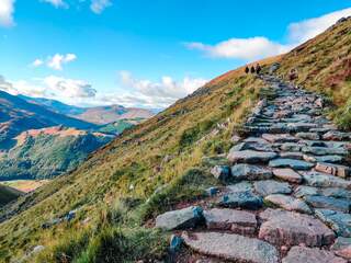
1. The West Highland Way
The West Highland Way is Scotland's most iconic long-distance hiking trail, stretching 96 miles (154 km) from the outskirts of Glasgow in Milngavie to the Highland hub of Fort William, at the foot of Ben Nevis-the UK’s tallest mountain. This legendary route is celebrated for its dramatic scenery, historical significance, and the sense of camaraderie it fosters among hikers from around the world.
Trail Highlights
- Diverse Landscapes:
- Traverse the tranquil woodlands and rolling farmland of the Lowlands.
- Walk along the bonnie banks of Loch Lomond, Scotland’s largest and arguably most beautiful loch.
- Cross the wild, windswept expanse of Rannoch Moor, famed for its remoteness and unique wildlife.
- Experience the dramatic peaks and valleys of Glencoe, steeped in both natural beauty and historical intrigue.
- Climb the Devil’s Staircase, the highest point on the trail at 550m (1,804ft), for panoramic Highland views.
Trail Experience
- Distance: 96 miles (154 km)
- Typical Duration: 6–8 days, though fit hikers sometimes complete it in less.
- Difficulty: Moderate to challenging. While much of the route follows well-marked paths, expect some rugged, rocky sections-especially north of Loch Lomond and through Glencoe.
- Elevation Gain: Approximately 3,900m (12,800ft).
- Best Time to Go: April to October for milder weather and longer daylight hours; May–June and September–October are ideal for avoiding the worst of the midges.
Accommodation Options
- Campsites:
- Beinglas Farm Campsite (near Inverarnan): Features a shop, bar, and restaurant.
- Glencoe Camping and Caravanning Club Site: Offers showers, toilets, laundry, and electric hook-ups.
- Other Options:
- Hostels, B&Bs, hotels, and glamping pods are available in most towns and villages along the route, including Drymen, Tyndrum, Bridge of Orchy, Kinlochleven, and Fort William.
- Wild camping is permitted in many areas, but be sure to follow the Scottish Outdoor Access Code.
Why Hike the West Highland Way?
- Natural Beauty: From serene lochs to rugged Highland peaks, the scenery is world-class and ever-changing.
- History & Culture: Pass ancient castles, historic battlefields, and the haunting Glencoe valley, site of the infamous 1692 massacre.
- Community: Meet fellow adventurers from across the globe. The trail’s popularity ensures a friendly, communal atmosphere.
- Accessibility: The route is well-marked and supported, with regular access to towns for supplies and transport links at both ends.
Notable Sections
- Milngavie to Drymen: Gentle introduction through farmland and woodland.
- Loch Lomond: Challenging, rocky paths with rewarding lakeside views.
- Rannoch Moor: Remote, atmospheric, and a true wilderness experience.
- Glencoe & Devil’s Staircase: The most dramatic scenery and the trail’s toughest climbs.
- Lairig Mòr to Fort William: Finish with a sense of achievement beneath the shadow of Ben Nevis.
The West Highland Way is more than just a walk-it's a rite of passage for backpackers in the UK, offering a perfect blend of adventure, culture, and unforgettable Highland scenery.
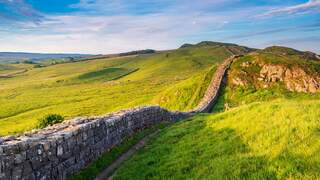
2. Hadrian’s Wall Path
Hadrian’s Wall Path offers a unique blend of history, scenery, and adventure across northern England. This 84-mile (135 km) National Trail traces the line of the Roman wall built nearly 2,000 years ago, running from Wallsend in Newcastle to Bowness-on-Solway on the Cumbrian coast. Along the way, you’ll encounter sweeping countryside, ancient ruins, and vibrant towns-making it a must for both history buffs and backpackers.
Trail Overview
- Length: 84 miles (135 km)
- Route: Wallsend (Newcastle) to Bowness-on-Solway (Cumbria)
- Typical Duration: 6–9 days, though experienced hikers may complete it in less time.
- Difficulty: Moderate; suitable for most reasonably fit walkers, but expect some steep, uneven sections-especially the “switchback” between Chollerford and Birdoswald.
- Waymarking: Well-marked with acorn symbols and arrows, making navigation straightforward.
Trail Highlights
- Segedunum Roman Fort, Baths and Museum:
- Trail’s eastern terminus in Newcastle. Explore reconstructed Roman baths, museum exhibits, and a model of the original fort.
- BALTIC Centre for Contemporary Art:
- Located along the River Tyne, this modern art gallery offers exhibitions, city views, and a lively café.
- Chesters Roman Fort:
- One of the best-preserved forts, with remains of barracks, headquarters, and Roman artefacts overlooking the River North Tyne.
- Housesteads Roman Fort:
- Set atop a ridge, this fort features panoramic views and well-preserved ruins, including a hospital and bakery.
- Vindolanda:
- A separate Roman settlement with extensive excavations, temples, and the famous Vindolanda tablets-offering a window into daily Roman life.
- Bowness-on-Solway:
- The western end of the trail, marked by a sculpture and a peaceful coastal setting. Relax in a local pub or explore the nearby nature reserve.
Walking Experience
- Landscape:
- The trail traverses moorland, rolling hills, farmland, and city streets. The central section, especially near Housesteads and Steel Rigg, is the most dramatic and where the wall is best preserved.
- Direction:
- The path can be walked in either direction, but most hikers start in the east at Wallsend and follow the wall’s original construction westward.
- Sections:
- The trail is commonly divided into six segments, each with distinct scenery and historical sites.
Accommodation and Facilities
- Campsites:
- Herding Hill Farm, Greenhead Camping and Caravanning Club Site, Winshields Campsite (Twice Brewed), and others offer pitches, amenities, and easy trail access.
- Other Options:
- Hostels, bunkhouses, B&Bs, and hotels are available in villages and towns along the route. Some are right on the trail, while others may require a short detour.
- Food and Supplies:
- Many villages have pubs, cafés, and shops. Some accommodations offer meals or are close to local dining options.
Why Choose Hadrian’s Wall Path?
- History:
- Walk alongside the best-preserved Roman frontier in Britain and a UNESCO World Heritage Site.
- Scenery:
- From rugged moorland to tranquil farmland and bustling cities, the route offers ever-changing vistas.
- Culture:
- Experience the hospitality of northern England, from lively Newcastle to quiet Cumbrian villages.
- Accessibility:
- Well-marked paths, frequent accommodation, and public transport links make it accessible for both experienced and first-time long-distance walkers.
Whether you walk the entire trail or just a section, Hadrian’s Wall Path delivers a journey through time and landscape-an unforgettable way to experience England’s heritage and natural beauty.
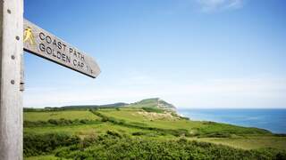
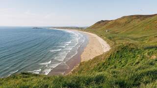
3. South West Coast Path
The South West Coast Path is the UK’s longest National Trail and a world-class adventure for backpackers. Stretching 630 miles (1,014 km) from Minehead in Somerset to Poole Harbour in Dorset, this epic route hugs the dramatic coastline of southwest England, weaving through Somerset, Devon, Cornwall, and Dorset. It’s a journey that promises breathtaking views, rich history, and a physical challenge like no other.
Trail Overview
- Length: 630 miles (1,014 km) – the longest established National Trail in the UK.
- Route: Minehead (Somerset) → Exmoor → North Devon → Cornwall → South Devon → Dorset → Poole Harbour.
- Elevation: Total ascent/descent is over 114,000 feet (35,000 m)-equivalent to climbing Mount Everest four times.
- Difficulty: Moderate to difficult, with frequent steep climbs, descents, and rugged terrain.
- Waymarking: Clearly signposted with acorn symbols; commemorative markers at Minehead (start), Porthallow (mid-point), and South Haven Point (end).
Walking Experience
- Duration: Walking the entire trail typically takes 45–55 days, averaging 11–14 miles per day, though you can easily break it into shorter sections.
- Direction: Most people walk anti-clockwise from Minehead to Poole, but it can be tackled in either direction.
- Sections: The path is divided into 52 official sections, each with its own map and guidebook.
- Highlights:
- Picturesque fishing villages, sandy beaches, and towering cliffs.
- Two UNESCO World Heritage Sites:
- Jurassic Coast (Dorset and East Devon): 185 million years of geological history.
- Cornwall and West Devon Mining Landscape: Celebrating the region’s industrial heritage.
- Historic landmarks: lighthouses, castles, ancient monuments, and remnants of the 19th-century Coastguard patrol route.
Accommodation Options
- Campsites:
- Over 275 campsites and holiday parks are dotted along the trail, ranging from basic pitches to glamping pods and family-friendly parks.
- Examples include Treen Farm Campsite, Trewethett Farm Caravan and Motorhome Club Site, East Crinnis Holiday Park, and Highlands End Holiday Park.
- Other Stays:
- B&Bs, inns, boutique hotels, hostels, and self-catering cottages are widely available, often with walker-friendly facilities.
- Booking ahead is advised, especially in peak season.
Why Walk the South West Coast Path?
- Scenic Variety:
- Experience wild moorland, secret coves, bustling harbours, and panoramic sea views.
- Wildlife & Nature:
- Spot seals, dolphins, seabirds, and rare wildflowers along the route.
- Cultural Richness:
- Pass through vibrant coastal towns, sample local seafood, and discover centuries of maritime history.
- Flexibility:
- Walk the entire path for the ultimate challenge, or choose a section that matches your time and ability.
- All Abilities Welcome:
- While the full route is demanding, many sections are suitable for families, beginners, or those seeking shorter scenic strolls.
Memorable Moments
- Stand atop Great Hangman, the trail’s highest point, for sweeping coastal vistas.
- Explore the fossil-rich cliffs of the Jurassic Coast.
- Enjoy a Cornish pasty in a harbour-side pub after a day’s hike.
The South West Coast Path is more than a trail-it’s an unforgettable journey through some of England’s most spectacular landscapes, offering adventure, history, and natural beauty at every turn.
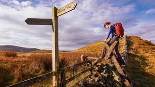
4. Pennine Way
The Pennine Way is the UK’s oldest and one of its most iconic long-distance trails, stretching 268 miles (431 km) from Edale in the Peak District to Kirk Yetholm in the Scottish Borders. Renowned for its wild beauty and physical demands, this legendary route is a true test for experienced walkers seeking a rewarding adventure across some of England’s most remote uplands.
Trail Overview
- Length: 268 miles (431 km)
- Route: Edale (Derbyshire) to Kirk Yetholm (Scottish Borders)
- National Parks: Passes through the Peak District, Yorkshire Dales, and Northumberland National Park
- Highest Point: Cross Fell (893 m / 2,930 ft)
- Total Ascent: Exceeds the height of Mount Everest (over 11,000 m / 36,000 ft)
- Difficulty: Moderate to strenuous; recommended for experienced long-distance walkers
- Typical Duration: 16–19 days for most walkers, but can be split into shorter sections
What Makes the Pennine Way Special?
- History:
- Opened in 1965 as the first National Trail in England and Wales, inspired by the Appalachian Trail in the US.
- The route was championed by journalist Tom Stephenson and paved the way for public access to England’s wildest landscapes.
- Landscape:
- Follows the “backbone of England”-the Pennine hills-through dramatic moorland, rugged valleys, and remote fells.
- Notable highlights include Kinder Scout, Malham Cove, Pen-y-ghent, High Cup Nick, Hadrian’s Wall, and the Cheviot Hills.
- Wildlife & Scenery:
- Encounter diverse wildlife, from curlews and grouse to mountain hares and wildflowers.
- Panoramic views, dramatic geology, and unspoilt scenery throughout.
Walking Experience
- Terrain:
- Varied and often challenging: expect steep climbs, long descents, boggy moorland, and exposed ridges.
- Weather can be unpredictable and severe, so good preparation and navigation skills are essential.
- The path is well-marked with acorn symbols, but a map and compass are still recommended.
- Stages:
- The trail is typically divided into 20 stages, each varying in length and difficulty.
- Rest days are advised in towns like Hebden Bridge, Hawes, Appleby, or near Hadrian’s Wall to explore and recover.
- Season:
- Can be walked year-round, but spring and autumn are generally best to avoid summer heat and winter cold.
Accommodation Options
- Campsites:
- Options like Crowden Camping and Caravanning Club Site and Low House Farm offer basic facilities (toilets, showers, water).
- Wild camping is possible if you follow the Countryside Code and leave no trace.
- Hostels & Bunkhouses:
- Hostels and bunkhouses are available in places like Alston, Dufton, Greenhead, Bellingham, and Kirk Yetholm, providing walker-friendly amenities such as drying rooms and communal areas.
- Other Stays:
- B&Bs, pubs, hotels, and guesthouses can be found in villages and towns along the route.
- Booking ahead is recommended, especially in remote sections with limited options.
Why Hike the Pennine Way?
- Ultimate Challenge:
- The toughest National Trail in England, ideal for those seeking to push their endurance and trekking skills.
- Historic and Cultural Riches:
- Walk through centuries of history, from ancient stone circles to Roman remains at Hadrian’s Wall.
- Unforgettable Scenery:
- Experience the wild heart of northern England, with landscapes that change dramatically from start to finish.
The Pennine Way is not for the faint-hearted, but for those who crave adventure, solitude, and the thrill of wild places, it offers a truly unforgettable journey-one that will test your limits and reward you with memories to last a lifetime.
5. The West Highland Way (Extended)
The West Highland Way (Extended) is a truly epic Scottish adventure, combining the classic 96-mile West Highland Way with a demanding 58-mile extension through the wild Knoydart Peninsula. This 154-mile route takes you from the outskirts of Glasgow all the way to one of Scotland’s most remote and beautiful wilderness areas, offering a journey through a rich tapestry of landscapes, history, and Highland culture.
The Knoydart Peninsula Extension
- Distance: Adds approximately 58 miles (93 km) through Knoydart, often called “Britain’s last wilderness”.
- Access:
- Only reachable by boat or on foot-there are no public roads into Knoydart.
- Scenery:
- Towering Munros, secluded lochs (Loch Arkaig, Loch Hourn, Loch Quoich), pristine beaches, and open moorland.
- Abundant wildlife: deer, golden eagles, otters, and even dolphins along the coast.
- Route Features:
- Follows ancient drove and military roads, rough mountain paths, and coastal tracks.
- Visits Inverie, the main village, home to the Old Forge-the most remote pub on mainland Britain.
- Passes through areas rich in clan history and Jacobite heritage.
- Challenges:
- Demanding ascents and descents, river crossings, and exposed ridges.
- Very remote terrain with no shops or regular services-walkers must be self-sufficient and prepared for sudden weather changes.
- Wild camping is the norm, with classic spots at Glen Kingie and Barrisdale Bay. Follow the Scottish Outdoor Access Code and always leave no trace.
Trail Experience and Logistics
- Difficulty:
- The extended trail is considered difficult and best suited to experienced, well-prepared hikers.
- Total ascent and descent each exceed 13,000 feet (4,000 m), with long, isolated stretches and challenging weather.
- Duration:
- The West Highland Way is typically completed in 6–8 days; the Knoydart extension adds several more days, depending on pace and chosen route.
- Accommodation:
- Official campsites, glamping pods, B&Bs, and hotels are available along the West Highland Way.
- In Knoydart, wild camping is essential, though Inverie offers limited hostel and B&B options.
- Preparation:
- Carry all necessary food, gear, and navigation tools for the Knoydart section.
- Be prepared for river crossings, boggy ground, and the possibility of midges and ticks in summer.
Why Choose the West Highland Way (Extended)?
- Unrivalled Scenery: Traverse a vast range of Scottish landscapes, from gentle lowlands to rugged mountains and untouched wilderness.
- True Wilderness: Experience the solitude and challenge of Knoydart, one of the UK’s last great wild places.
- Cultural Richness: Encounter clan history, ancient paths, and the welcoming Highland spirit in remote villages and bothies.
- Adventure: This route promises a genuine test of endurance, self-sufficiency, and outdoor skills-rewarding you with memories and views that few others will ever experience.
The West Highland Way (Extended) is a bucket-list journey for serious backpackers. It’s a trail that will challenge, inspire, and immerse you in the wild heart of Scotland.
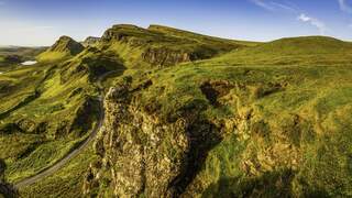
6. The Skye Trail
The Skye Trail is an unofficial, challenging long-distance route that traverses the Isle of Skye from north to south, covering approximately 128 km (about 80 miles) of some of the UK’s most spectacular and rugged landscapes. Designed for experienced hillwalkers, this trail offers a true wilderness adventure, combining dramatic mountain ridges, remote coastal cliffs, and haunting reminders of the island’s turbulent history.
Trail Overview
- Distance: 128 km (80 miles)
- Duration: 5 to 7 days, depending on pace and weather
- Start/End Points: Rubha Hunish (north) to Broadford (south), though the route can be walked in either direction
- Waymarking: None – the trail is unmarked and often pathless, requiring strong navigation skills and self-sufficiency
- Difficulty: Hard – suitable only for experienced walkers comfortable with rough terrain, river crossings, and rapidly changing weather
Route Highlights
- Trotternish Ridge:
- One of the UK’s most celebrated escarpments, featuring iconic landmarks such as the Old Man of Storr, the Quiraing, and the Needle.
- Offers dramatic views, unique rock formations, and a sense of exposure on high, narrow ridges.
- The Cuillin:
- The route passes beneath the jagged Black Cuillin, widely regarded as Britain’s finest mountains.
- Admire their rocky pinnacles and deep corries from below, or detour for a climb if you have the skills and equipment.
- Coastal Cliffs and Paths:
- Traverse little-visited cliffs and airy coastal trails, especially on the approach to Elgol – a section requiring great care.
- Enjoy stunning vistas over Loch Coruisk and the surrounding seascapes.
- Deserted Villages:
- Pass through haunting ruins of villages like Boreraig and Suisnish, cleared during the Highland Clearances, offering a poignant glimpse into Skye’s past.
- Charming Villages:
- Portree (the island’s capital) and Broadford offer shops, cafés, pubs, and accommodation for rest and resupply.
Typical Stages
While the Skye Trail can be divided flexibly, a common 7-stage breakdown is:
- Rubha Hunish to Flodigarry (12 km)
- Flodigarry to The Storr (27 km)
- The Storr to Portree (14 km)
- Portree to Sligachan (19 km)
- Sligachan to Elgol (18 km)
- Elgol to Torrin (16.5 km)
- Torrin to Broadford (20 km)
Essential Information
- Navigation:
- The route is not waymarked and often lacks a clear path, especially on the Trotternish Ridge and remote coastal sections. A detailed map and compass (or GPS) are essential
- Terrain:
- Expect steep ascents and descents, exposed ridges, boggy ground, and river crossings that can become impassable in poor weather.
- Camping:
- Wild camping is permitted and often necessary. Choose your spots with care and always follow Leave No Trace principles
- Weather:
- Skye’s weather is famously unpredictable – be prepared for wind, rain, and low visibility at any time of year.
- Supplies:
- Shops and services are limited outside Portree and Broadford. Plan food and gear resupplies carefully.
Why Walk the Skye Trail?
- Unrivalled Scenery: Traverse some of the UK’s most breathtaking mountain and coastal landscapes, with ever-changing views and dramatic geology.
- Solitude and Wilderness: Escape the crowds and immerse yourself in remote, wild country where you may walk all day without seeing another soul.
- Rich History: Walk through the remnants of deserted villages and learn about the island’s storied past, from clan feuds to the Highland Clearances.
- Adventure: The Skye Trail is a true test for experienced backpackers, offering both challenge and immense reward for those who take it on.
The Skye Trail is not for beginners, but for seasoned walkers seeking a wild, unforgettable journey through the heart of Scotland’s most atmospheric island, it’s an experience like no other.
7. The Coast to Coast
The Coast to Coast Walk is one of Britain’s most celebrated long-distance trails, offering a true cross-country adventure from the Irish Sea to the North Sea. Devised by renowned fell walker Alfred Wainwright in 1973, this 192-mile (309 km) journey leads you from the coastal village of St Bees in Cumbria to the picturesque Robin Hood’s Bay in North Yorkshire. Along the way, you’ll traverse three spectacular national parks, experience diverse landscapes, and immerse yourself in the culture and history of Northern England.
Trail Overview
- Distance: 192 miles (309 km)
- Route: St Bees (Cumbria) to Robin Hood’s Bay (North Yorkshire)
- Typical Duration: 12–15 days, though some walkers take longer to enjoy rest days and sightseeing.
- Direction: Most walkers go west to east, starting at St Bees and finishing at Robin Hood’s Bay, following Wainwright’s original route for the best progression of scenery and to finish with the sunrise over the North Sea.
- Difficulty: Moderate to difficult, with steep climbs, rocky paths, and variable weather.
Route Highlights
- Three National Parks:
- Lake District: Dramatic mountains, sparkling lakes, and classic fell scenery.
- Yorkshire Dales: Rolling hills, limestone pavements, and charming stone villages.
- North York Moors: Expansive heather moorland and sweeping coastal views.
- Highest Point: Kidsty Pike in Cumbria, at 2,560 feet (780 metres).
- Historic Villages and Sites:
- Pass through Grasmere, Richmond, and other villages rich in history and local hospitality.
- Visit ruins, castles, and sites linked to England’s literary and industrial heritage.
Walking Experience
- Stages:
- Wainwright’s original guide divides the walk into 12 stages, each ending in a settlement with accommodation.
- Many walkers opt for 14–15 days, splitting longer sections for a more relaxed pace and adding rest days in scenic spots.
- Traditions:
- Begin by dipping your boots in the Irish Sea at St Bees and collecting a pebble.
- End by wetting your boots in the North Sea at Robin Hood’s Bay and leaving your pebble behind.
- Navigation:
- The route is not an official National Trail (though it is set to become one in 2025), so waymarking is limited. Good maps, guidebooks, or GPS are recommended.
Accommodation Options
- Campsites:
- Numerous campsites line the route, such as Langdale Campsite and Blakey Ridge Camping and Caravanning Club Site, as well as camping barns and pods for added comfort.
- B&Bs and Guesthouses:
- Cosy, walker-friendly options are plentiful in villages and towns along the trail, offering a warm welcome and hearty breakfasts.
- Inns, Hotels, and Hostels:
- Choose from rustic inns, comfortable hotels, and affordable hostels (like YHA Black Sail in Ennerdale or Grasmere) for a variety of experiences and budgets.
- Wild Camping:
- While not officially permitted in England without landowner permission, wild camping is often tolerated in remote areas if you follow ‘leave no trace’ principles.
Why Walk the Coast to Coast?
- Diverse Scenery:
- Experience the changing face of Northern England, from rugged mountains and serene lakes to lush dales and wild moorland.
- Cultural and Historical Richness:
- Walk through centuries of history, from ancient stone circles to literary landmarks and traditional pubs.
- Personal Challenge:
- The route is physically and mentally demanding, but the sense of achievement at Robin Hood’s Bay is unforgettable.
- Flexibility:
- Customise your itinerary, accommodation, and daily mileage to suit your pace and interests.
Fun Facts
- Named the world’s second-best walk by a panel of experts in 2004.
- The fastest completion time is just over 39 hours, but most walkers take two weeks to savour the journey.
- The route will become an official National Trail in 2025, with upgrades to waymarking and facilities underway.
The Coast to Coast Walk is a once-in-a-lifetime trek that showcases the very best of England’s landscapes, heritage, and hospitality. Whether you’re seeking a physical challenge, a cultural journey, or simply a chance to “stand and stare,” this iconic trail delivers an experience you’ll never forget.
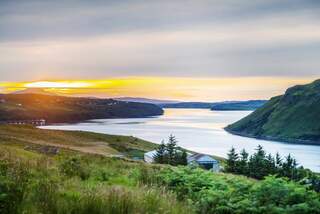
8. The West Highland Way and the Great Glen Way
For hikers craving a truly immersive Scottish adventure, combining the West Highland Way and the Great Glen Way creates a 135-mile (217 km) journey through some of the country’s most iconic and beautiful landscapes. This extended trek links two of Scotland’s best-loved long-distance trails, taking you from the outskirts of Glasgow all the way to Inverness, the capital of the Highlands.
Trail Overview
- Total Distance: Approximately 135 miles (217 km)
- Route: Milngavie (near Glasgow) → Fort William (via West Highland Way) → Inverness (via Great Glen Way)
- Typical Duration: 10–14 days, depending on pace and rest days
- Difficulty: Moderate to difficult; suitable for fit, well-prepared walkers
Great Glen Way Highlights
(73–79 miles / 117–127 km: Fort William to Inverness)
- Begin in the shadow of Ben Nevis and follow the Great Glen, Scotland’s most famous geological fault line
- Walk along the Caledonian Canal, past Neptune’s Staircase (the UK’s longest staircase lock)
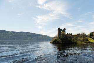
- Trace the shores of Loch Lochy, Loch Oich, and the legendary Loch Ness
- Enjoy forest tracks, canal towpaths, and the option of high-level routes for dramatic views above Loch Ness
- Finish in Inverness, with its lively city centre and riverside setting
Walking Experience
- Terrain:
- The West Highland Way features rugged paths, rocky terrain, and some steep ascents and descents, especially in the northern stages.
- The Great Glen Way is mostly low-level, following canal towpaths and forest tracks, but offers optional high-level sections between Fort Augustus and Drumnadrochit for more experienced walkers.
- Weather:
- Be prepared for rapid changes and potentially challenging conditions, especially in remote sections.
- Navigation:
- Both routes are well-marked, but always carry a map, compass, or GPS for safety.
Accommodation Options
- Campsites:
- Along the route, you’ll find campsites such as Loch Oich Caravan and Camping Park and Abriachan Eco Campsite, as well as many others near towns and villages.
- Other Stays:
- B&Bs, hostels, hotels, and glamping pods are available throughout, offering a range of comfort and price points.
- Wild Camping:
- Permitted in many areas, especially on the West Highland Way, provided you follow the Scottish Outdoor Access Code.
Route Logistics
- Direction:
- Most hikers start in Milngavie and finish in Inverness, walking north-east with the prevailing wind and sun at their backs.
- Stages:
- The West Highland Way is commonly split into 7–8 stages; the Great Glen Way into 5–7 stages. Both can be customized based on ability and interest.
- Resupply:
- Regular opportunities to restock food and supplies in towns such as Fort William, Fort Augustus, Drumnadrochit, and Inverness.
Why Combine These Trails?
- Iconic Scenery:
- Experience the best of Scotland’s lochs, glens, mountains, and forests in one continuous journey.
- Wildlife:
- Spot deer, eagles, osprey, pine marten, and maybe even Nessie in Loch Ness.
- History and Culture:
- Pass ancient castles, battlefields, and villages steeped in Highland lore.
- Sense of Achievement:
- Completing both trails in one trip is a major accomplishment and offers a deep connection to the Scottish landscape.
Tips for Success
- Plan your daily mileage and accommodation ahead, especially in peak season.
- Prepare for changeable weather and bring appropriate gear for rain, wind, and cool nights.
- Take time to enjoy the views, local food, and Highland hospitality along the way.
The West Highland Way and Great Glen Way combo is a rewarding, memorable experience for any backpacker seeking the ultimate Scottish long-distance hike-a journey filled with natural wonders, adventure, and a true sense of achievement.
Shop Our Outdoor Footwear Range
To check out more from our footwear range, click below to shop the entire collection...
Backpacking in the UK FAQs
The UK is home to legendary trails like the West Highland Way, Hadrian’s Wall Path, South West Coast Path, Pennine Way, Coast to Coast Walk, Cumbria Way, Cape Wrath Trail, and The Ridgeway. Each offers unique scenery, history, and challenges for backpackers of all levels.
The West Highland Way is a popular choice for beginners due to its well-marked paths, varied landscapes, and accessible campsites and inns. This 96-mile route from Glasgow to Fort William is social, scenic, and manageable for those new to multi-day hiking.
Yes, the Cape Wrath Trail in Scotland is considered Britain’s toughest, stretching 230 miles through rugged, remote landscapes. It requires advanced navigation, self-sufficiency, and good fitness, rewarding experienced hikers with world-class mountain scenery and solitude.
Devised by Alfred Wainwright, the Coast to Coast Walk traverses 182 miles from St Bees Head to Robin Hood’s Bay, crossing the Lake District, Yorkshire Dales, and North York Moors. It’s celebrated for its diverse scenery, charming villages, and the sense of journey across England.
Booking accommodation in advance is recommended, especially during peak season. While many trails offer campsites, hostels, and B&Bs, popular routes can fill up quickly. Planning ahead ensures you have a place to rest each night and can tailor your itinerary to your pace.
Pack a sturdy backpack, waterproof clothing, reliable footwear, sleeping bag, tent or shelter, navigation tools (map and compass), first aid kit, and plenty of food and water. Weather can be unpredictable, so layering and rain protection are crucial for comfort and safety.
Related Articles


Let us know you agree to cookies
We use marketing, analytical and functional cookies as well as similar technologies to give you the best experience. Third parties, including social media platforms, often place tracking cookies on our site to show you personalised adverts outside of our website.
We store your cookie preferences for two years and you can edit your preferences via ‘manage cookies’ or through the cookie policy at the bottom of every page. For more information, please see our cookie policy.